About Kargil
Kargil has a long and fascinating history with various dynasties and as a hub for trans-continental Silk Route trade that linked Central Asia, the Indian subcontinent and the world beyond. Its history is still evident in the forts and palaces that dot its landscape, ancient rock carvings and petroglyphs, and rich diversity of linguistic, social, religious and ethnic communities found in Kargil today. In addition to its cultural and spiritual heritage, Kargil’s rugged landscape is ideal for adventure activities such as mountaineering, trekking, river rafting, rock-climbing, ice hockey, ice skating, speed skating, and snow skiing. Kargil is located at the threshold of several biogeographic and is home to species native to Central Asia, Tibet and alpine Himalayan ecosystems. This includes large, charismatic species such as snow leopards (Panthera uncia), Himalayan brown bear (Ursus arctos),ibex (Capra ibex sibirica) and a rich diversity of bird and plant-life. Kargil is also an important frontier region that gained international fame due to the Indo-Pakistan war in 1999 over control of strategic mountain ridges along the Line of Control that separates them. This war is popularly called the Kargil War and several battle sites such as Tiger Hill, Drass, Batalik, Tololing are well-known across India. Kargil offers something for everyone, be it history, culture, nature, adventure or social heritage.
Kargil is made up of a series of valleys, with each having its own unique history, geographical speciality and distinctive culture.
Drass: This is the westernmost part of Kargil district and borders Kashmir valley. The highway that connects Kashmir and Ladakh reaches Drass after crossing Zoji-la, which also allows moisture-laden clouds through. As a result, Drass receives more snowfall that other parts of Ladakh. Most residents of Drass belong to the Dardic community. It is famous for horse polo, ice hockey and for the war memorial dedicated to the martyrs of the 1999 war. Kargil town: Kargil town is located on the banks of the Suru river, which is an important tributary of the Indus. A number of valleys such as Sodh, Suru, and Drass meet at Kargil town. In the past, Kargil town served as a meeting place for traders from Kashmir, Punjab, Baltistan, Zangskar, Leh, Sinkiang (presently Xinjiang) to exchange goods and ideas. This history is reflected in the diversity of communities that call Kargil home.
Suru valley: Suru valley extends from Kargil town to Zangskar valley. It’s in the rain shadow of the Great Himalayan Range and receives relatively higher levels of moisture than other regions. It’s one of the most fertile and productive regions in Ladakh. It has a long history of trade with different regions in Ladakh as well as Kashmir and Kishtwar located on the other side of the Himalayas.
Zangskar: Zangskar valley is an isolated area south of Suru valley. Zangskar enjoys sub-divisional status within Kargil district and shares borders with Himachal Pradesh in the south, Kishtwar in the west and Leh district in the east. Zangskar is primarily Buddhist with a small Muslim population in Padum, the sub-divisional headquarters. The main access road to Zangskar comes over Penzi-la and connects it with Kargil town. When this pass gets blocked in the winter, Zangskar becomes isolated till it opens again in summer. During the winter, this valley can only be accessed by air or by trekking over the frozen Zangskar river (Chadder trek).
Sodh: Sodh is the area east of Kargil town, which was part of the famous Chiktan dynasty founded by Tha Tha Khan. The area is dotted by numerous villages and includes several palaces and sites of spiritual importance.
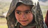
Darchiks-Garkone-Batalik: These villages are located along the Indus and inhabited by Dardic communities. These areas are located at lower elevations than other regions in Ladakh and are equally famous for the quality of their vegetables, flowers and fruits as they for the unique culture of the Dardic community.
Shakar-Chiktan: This area is often regarded as the cultural heartland of Purig. Many of Kargil’s traditional songs and dances find their origin in this valley. It is also home to several spectacular palaces and forts. Another interesting aspect of this region is their time-tested legacy of communal harmony between their mixed population of Buddhists and Muslims, especially in Kuksho and Dargo villages.
Wakha-Mulbekh: The origins of these villages go back several centuries but little is known of its early history. For instance, the sculptors who carved the Buddhist Chamba in Mulbekh remain shrouded in mystery and it has several elements that pre-date the influence of Tibetan Buddhism in Ladakh
Shargole-Sapi: Shargole is located on a side valley from the road that connects Wakha-Mulbekh and Kargil town. This area was an independent kingdom and conducted regular trade with Suru valley, which is located to its west. The area is famous for its important Buddhist paintings, the alpine lake called Sapi-Tso and its rich diversity of herbs.Communities of Kargil
Technically, Purig-pa refers to all residents of Kargil district. It is commonly used to refer to Kargili residents who belong to Tibeto-Mongol ethnicity
The Dards are said to be the original inhabitant of Ladakh and trace their origins in Gilgit. They are believed to belong to the Caucasian race, while other communities in Ladakh are of Tibeto-Mongol origins. This community have been divided into small sub-groups, such as Shin, Yashkon, Karamen and Dom. Overtime, many of them have adopted Islam and Buddhism, while some still follow their traditional animistic beliefs and practices (Bon-chos).
The Zangskar-pas are residents of Zangskar valley, who share cultural and linguistic traits with neighbouring regions of Kishtwar (Jammu) and Lahoul (Himachal Pradesh).
This group shares cultural, linguistic and social traits with the people of Baltistan. Several villages in Kargil still retain their traditional Balti practices and dialect.
In various Tibetan dialects, ‘Hor’ refers to Central Asia. There are numerous families in Kargil who trace their origins in Central Asia and have now become assimilated in Kargili society.
There is also a small Sikh community in Kargil, whose ancestors were involved in the Silk Route trade. These families arrived in Ladakh as traders and stayed back even after the trade between Central Asia and the Indian subcontinent ceased in the mid- Twentieth Century.
Anim pariatur cliche reprehenderit, enim eiusmod high life accusamus terry richardson ad squid. 3 wolf moon officia aute, non cupidatat skateboard dolor brunch. Food truck quinoa nesciunt laborum eiusmod. Brunch 3 wolf moon tempor.